

The new study “Unburnable carbon in the rapidly warming Arctic: mapping spatial relationships among oil and gas development, ecologically sensitive areas, and Indigenous Peoples’ lands” coordinated by Daniele Codato, Daniele Vezzelli, Federica Ammaturo, Giorgia Lazazzera, Andrea Stralla, Salvatore Eugenio Pappalardo, and Massimo De Marchi of the Jean Monnet Centre of Excellence on Just Fossil Fuel Transitions and the “Climate Change, Territories, and Diversity” research group of the Department of Civil, Environmental and Architectural Engineering (DICEA) of the University of Padua, has been published in the journal PLOS One. This study presents the first comprehensive geographic atlas of oil and gas activities in the Arctic, offering an unprecedented view of the interactions between resource exploitation, fragile ecosystems and indigenous peoples’ lands.
The research uses open-access geospatial data from five Arctic countries (USA, Canada, Greenland, Norway, and Russia) and a GIS-based geovisualization approach. The goal is to map the distribution of concessions, infrastructure and mining activities, highlighting their overlap with ecologically sensitive areas and indigenous territories.
A climate and geopolitics hotspot
The study comes at a particularly critical geopolitical moment: the Arctic is warming at a rate nearly four times faster than the global average, simultaneously becoming a frontline for both the climate crisis and the expansion of extractive activities. Melting ice is opening up new trade routes and opportunities for resource exploitation, while intensifying pressure on extremely vulnerable ecosystems.
At the same time, the region is at the centre of growing geopolitical tensions, with global powers competing for control of resources and strategic shipping routes. This context risks marginalizing climate priorities, despite the urgent need to drastically reduce fossil fuel use to meet the 1.5 °C target of the Paris Agreement.
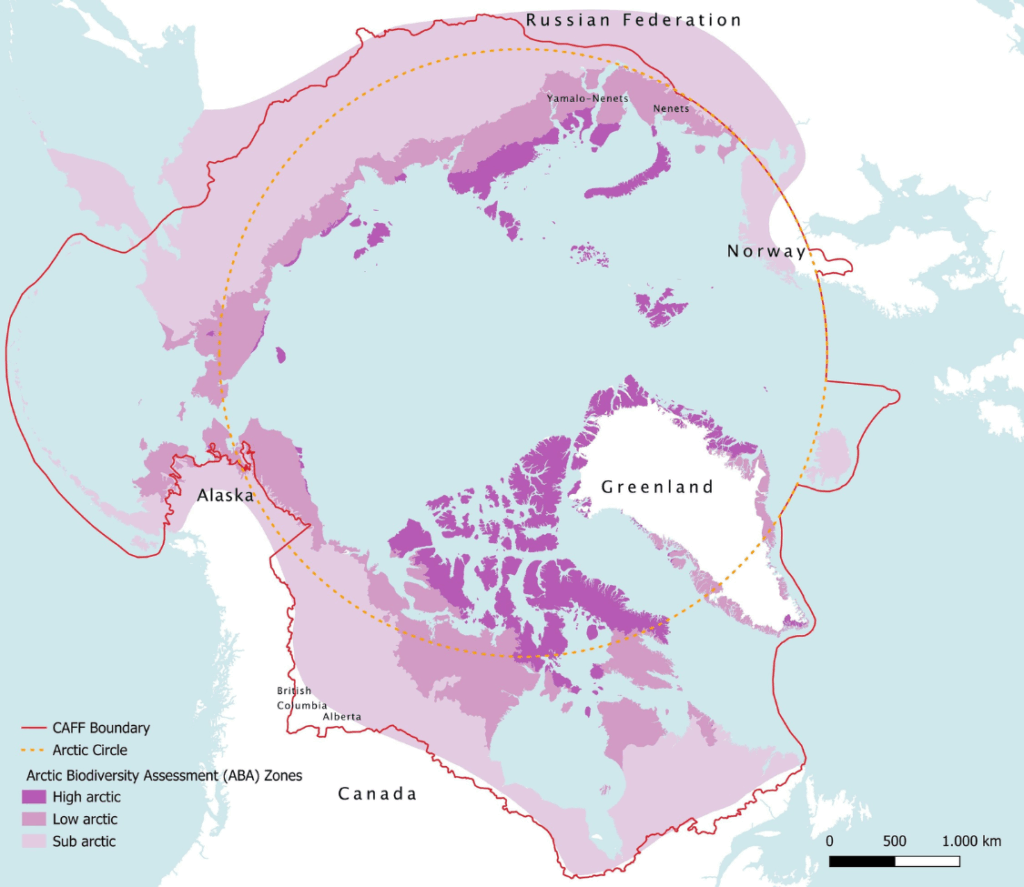 Study area framework
Unburnable carbon in the spotlight
The key concept highlighted by the study is that of unburnable carbon: a significant portion of global fossil fuel reserves, particularly those in the Arctic, must remain untapped to avoid catastrophic climate scenarios. Arctic resources, in addition to being highly expensive and technically difficult to extract, are among the most incompatible with climate objectives.
The expansion of infrastructure (wells, pipelines, seismic monitoring) also has direct impacts on ecosystems: habitat fragmentation, alteration of migratory routes and disruption of traditional activities of indigenous communities, such as hunting, fishing and reindeer herding.
The numbers of exploitation
The analysis highlights the vast scale of extractive activities in the Arctic (considered according to the geographical definition of the Arctic Council’s Conservation of Arctic Flora and Fauna working group, which combines climatic, biological and geographical aspects):
– 512,306 km² covered by oil and gas concessions (an area comparable to Spain);
– 44,539 active wells, 39,535 km of pipelines, 1.95 million km of seismic monitoring lines, equivalent to almost 48 times the Earth’s circumference.
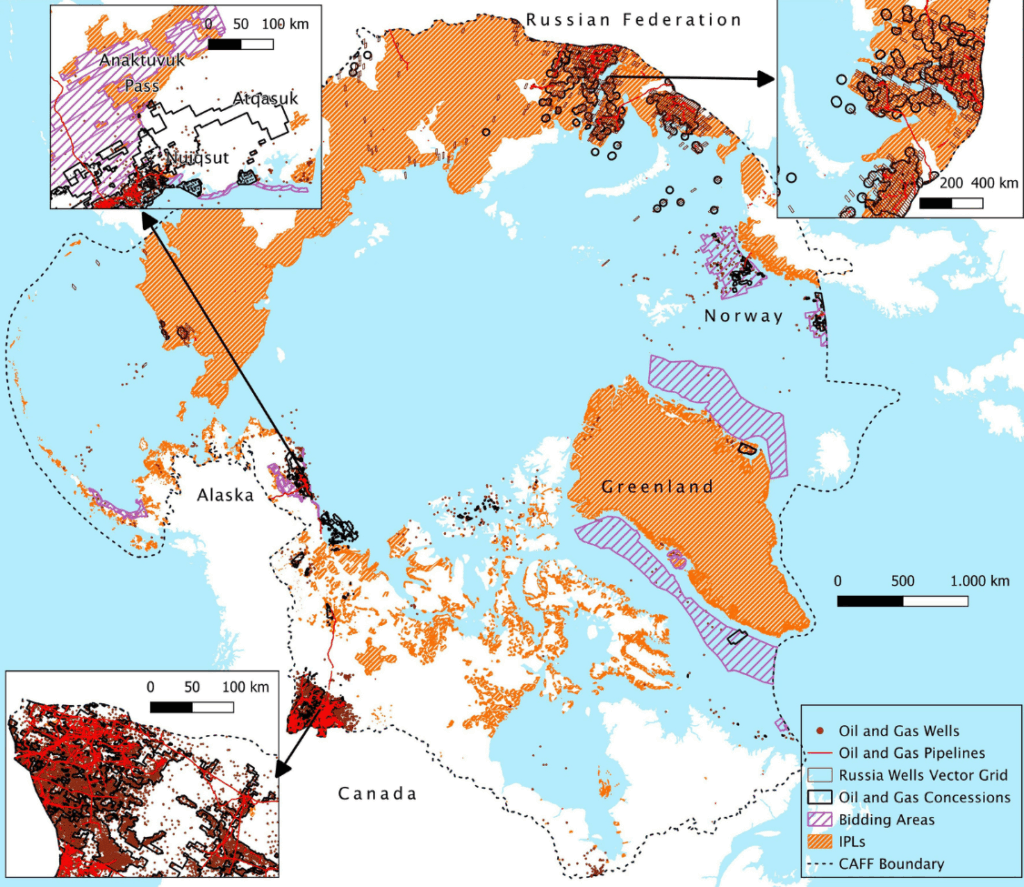
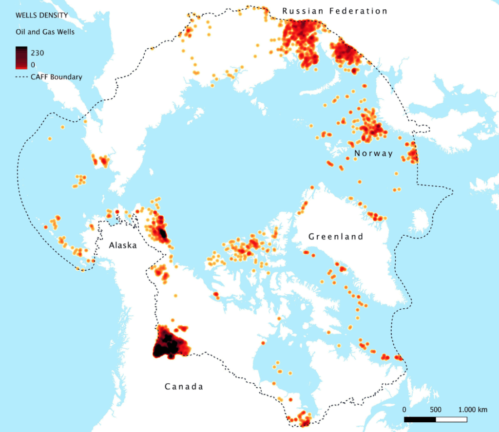 Map of oil and gas wells density in the Arctic region
Critical overlaps with ecosystems and communities
One of the most significant findings concerns the spatial overlap between extractive activities and areas of ecological and cultural value:
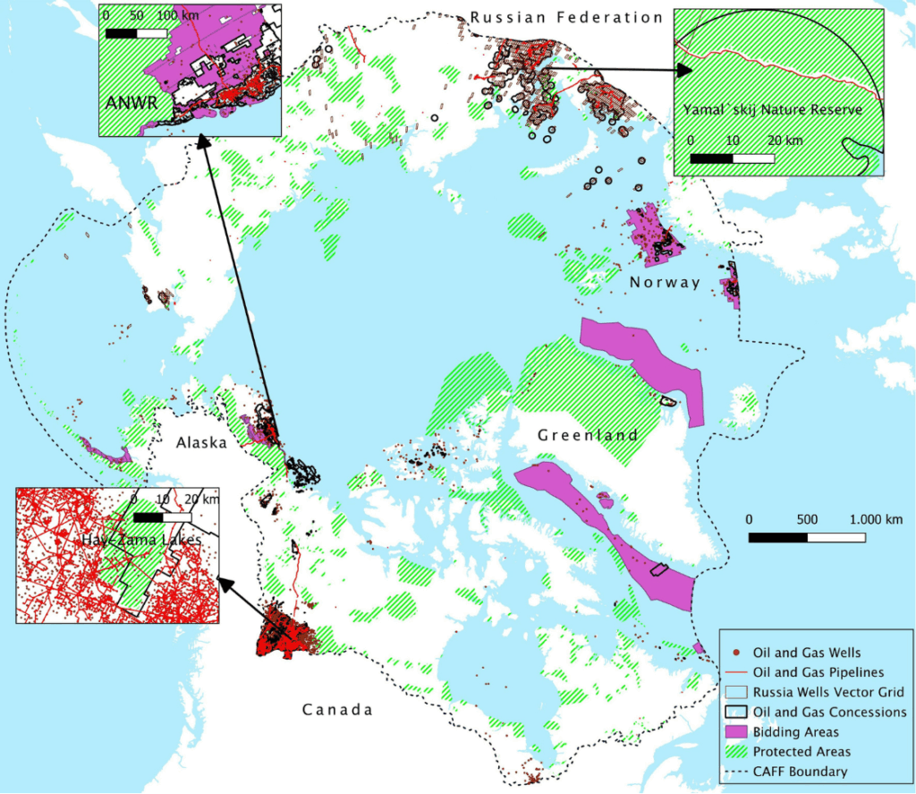
– 73.3% of concessions overlap with indigenous peoples’ lands;
– 7.57% involve protected areas;
– many activities coincide with the habitats of key species such as polar bears, caribou, and arctic birds.
Even where there is no direct overlap, the proximity of infrastructure and sensitive areas indicates potential long-term socio-ecological pressures.
The areas with the highest concentration of activities include the Yamal Peninsula in Russia, the western provinces of Canada and the North Slope of Alaska, regions characterized by fragile ecosystems and the presence of indigenous communities.
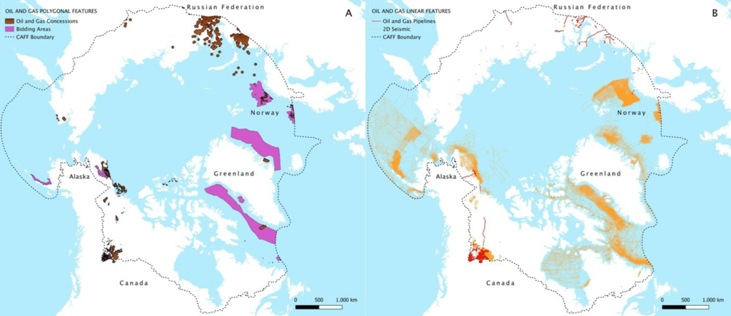 Map of oil and gas polygonal features in the Arctic region (L) and map of oil and gas linear features in the Arctic region (R)
 Map of oil and gas features and protected areas in the Arctic region
Supporting more equitable and sustainable policies
The atlas represents an innovative tool to support policymakers, researchers and local communities by making the spatial relationships between resource exploitation, biodiversity and land rights visible. The study introduces spatial justice criteria to identify priority areas where fossil resources should remain underground.
The research also highlights significant gaps in data availability and transparency, especially in Russia, underscoring the need for improved monitoring and governance of extractive activities.
 Map of oil and gas features and Indigenous Peoples Land in the Arctic region
Towards an “Arctic Fossil Fuel Non-Proliferation Zone”
Among future prospects, the proposal to establish a “fossil fuel non-proliferation zone” in the Arctic stands out, in line with similar global initiatives such as the Fossil Fuel Treaty. This approach is based on climate, economic and ecological evidence: high extraction costs, the risk of stranded assets, ecosystem vulnerability and the political precedent of moratoria already adopted in some countries.
The study also contributes to the European debate on the update of the European Union’s Arctic policy (scheduled for 2026), contributing recommendations that include strengthening the scientific basis for decisions, respecting the rights of indigenous peoples and adopting measures to limit further fossil fuel development in the region.
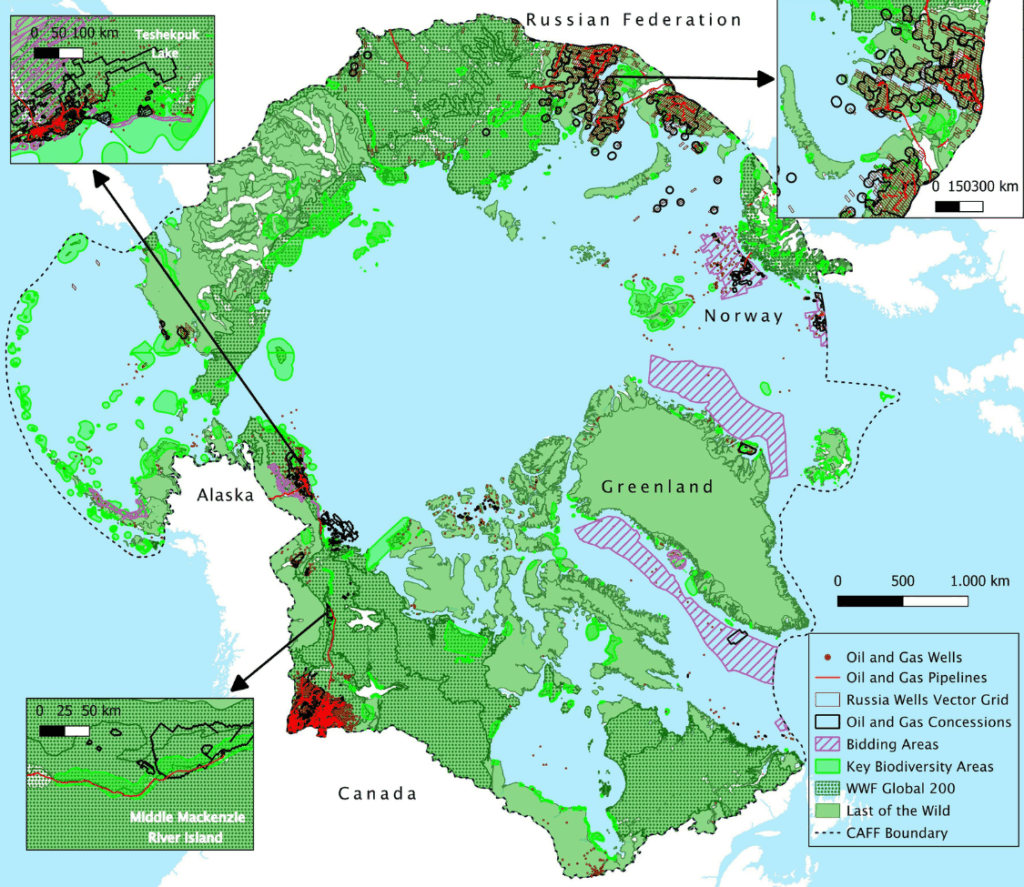 Overlap between oil and gas wells and facilities and areas recognized as conservation priorities
From research to action
The findings will also be at the center of international debate during the first global conference on the transition from fossil fuels, “Transitioning Away from Fossil Fuels” scheduled for April 24-29 2026, in Santa Marta, Colombia.
On April 29, the Jean Monnet Center of Excellence on Just Fossil Fuel Transitions will co-organize the parallel event “Between Amazon and Arctic: Place-based just fossil fuel transitions away. Panel on: geovisualization of yasunization multitudes“.
The panel will discuss the urgency of a just energy transition, analyzing the phase-out of fossil fuels from a contextualized perspective. Taking the Arctic and Amazon as emblematic regions of transformation, the dialogue transcends the local to explore “yasunization” as a global phenomenon of social mobilization generated by numerous grassroots initiatives. The role of geovisualization tools in mapping the multitude of narratives driving this change will be explored. Through a panel of people engaged in research and activism, the tensions between extractive policies and community-based alternatives will be discussed, highlighting how visual data can strengthen political advocacy and environmental justice in the diverse territories shaping these transitions.
Download the press release:
Comunicato stampa ITALIANO
Press release ENGLISH
Comunicado ESPANOL
Download the full article: